Flooding prompts activation of new Santa Fe idle-speed, no-wake zone
Published 2:13 pm Monday, February 15, 2016
- New Santa Fe River Zones
Because of recent rains and rising water levels, the Santa Fe River’s new Zone 8 is now above 17 feet, activating the idle-speed, no-wake zone, according to Florida Fish and Wildlife Conservation Commission (FWC) officials.
This area of the river becomes an idle-speed, no-wake zone when the Santa Fe River reaches 17 feet as indicated on the Three Rivers gauge, where flood stage is 19 feet.
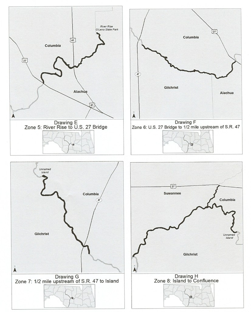
Zone 8 begins at an unnamed island located approximately 4.25 miles upstream from the confluence of the Santa Fe and Ichetucknee rivers (coordinates: 29° 54.527’ N, 82° 46.074’ W) and ends at the confluence of the Suwannee and Santa Fe rivers. This includes the Ichetucknee River upstream to the U.S. 27 Bridge.
“Zone 8 reached that level Saturday,” said Capt. Martin Redmond, area supervisor at the FWC’s Lake City office.
An idle-speed, no-wake zone means a vessel must proceed at a speed no greater than required to maintain steerageway and headway. At no time is any vessel required to proceed so slowly the operator is unable to control it or anything it may be towing.
“The higher water levels can create navigational hazards, such as floating debris, rocks, stumps and shoaling conditions for unsuspecting boaters,” Redmond said. “We want to work toward avoiding any tragedy that could be caused by operating a vessel at an unsafe speed during a high water event.”
FWC officers will be taking an educational approach and are asking for the public’s cooperation. Encounters involving careless, reckless and-or impaired operation will result in law enforcement action.
“We want to inform both boaters on the river and those who live along it of the rule changes and their value,” Redmond explained.
The idle-speed, no-wake zone will stay in effect until the water level recedes below 17 feet.
The other zones on the Santa Fe are:
- Zone 5: From the Santa Fe River at the River Rise in O’Leno State Park downstream to the center line of the U.S. 27 Bridge when the river is 35 feet or higher on the High Springs gauge.
- Zone 6: From the centerline of the U.S. 27 Bridge downstream to ½ mile upstream from the S.R. 47 Bridge when the river is 24 feet or higher on the Fort White gauge
- Zone 7: From ½ mile upstream of the S.R. 47 Bridge, downstream to an unnamed island located at 29° 54.527’ N, 82° 46.074’ W when the river is 19.5 feet at the Three Rivers Estates gauge.
Zones on the Suwannee River are:
- Zone 1: From the U.S. 90 Bridge at Ellaville south to the S.R. 51 Bridge at Luraville. This 39-mile segment becomes an idle-speed, no-wake zone when the Suwannee River reaches 47 feet or more above mean sea level at the Ellaville gauge, where flood stage is 54 feet.
- Zone 2: From the S.R. 51 Bridge at Luraville to Little River Spring. This 18-mile segment becomes an idle-speed, no-wake zone when the Suwannee River reaches 26 feet or more above mean sea level at the Branford gauge, where flood stage is 29 feet.
- Zone 3: From Little River Spring to the County Road 340 Bridge at Rock Bluff. This 23-mile segment becomes an idle-speed, no-wake zone when the Suwannee River reaches 24 feet or more above mean sea level at the Branford gauge.
- Zone 4: From the centerline of the C.R. 340 Bridge at Rock Bluff to approximately 300 feet southwest of the New Clay Landing Boat Ramp; from approximately 6,000 feet north of the Camp Azalea Boat Ramp to approximately 1,300 feet south of the Yellow Jacket Landing; and from approximately 2,000 feet northeast of the Fowler’s Bluff Boat Ramp to approximately 1ne mile southwest of the Fowler’s Bluff Boat Ramp when the river level is 9 feet or higher on the Wilcox gauge.
For more information about the flood zones, please call 386-758-0525. To report violations, please call 888-404-3922.
To obtain real-time river levels, visit www.mysuwanneeriver.com.