Dorian projected to arrive later in week
Published 9:49 am Friday, August 30, 2019
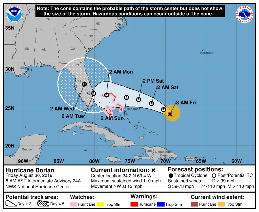
- The National Hurricane Center has Dorian moving slower on its path to Florida and through the state.
JACKSONVILLE — According to the National Weather Service and National Hurricane Center, impacts Hurricane Dorian won’t arrive in North Florida until later next week.
Dorian, which was upgraded to a Category 2 hurricane overnight, is now forecast to make landfall Tuesday in south Florida as a Category 4.
It will then slowly make its way north through the state, although its path is not known with the cone including from the Atlantic coast to the Gulf coast.
The Suwannee Valley is projected to receive between 3-6 inches of rain with localized heavier totals of up to 10 inches possible Wednesday through Friday.
Tropical storm force winds could reach the area as soon as Wednesday, between 6 a.m. and 6 p.m.
“It’s slowed down,” Sheriff Sam St. John, Suwannee County’s emergency management director, said following a Friday morning conference call with the National Weather Service in Jacksonville.
“Nothing has really changed. It’s just slowed down and not coming to us as quick.”
The Suwannee County Board of County Commissioners declared a local state of emergency Thursday morning, which is in effect for a week. Mayor Frank Davis also signed a state of emergency declaration for the City of Live Oak on Thursday morning effective until the threat from the storm passes.
The state of emergency ensures that the county is able to take steps to help mitigate potential damage from Hurricane Dorian.
Gov. Ron DeSantis declared a state of emergency for 26 Florida counties on Wednesday and extended it to the entire state Thursday.
Suwannee County officials also decided Thursday morning at their emergency meeting at the county’s Emergency Operations Center to provide sand for sandbags at the Live Oak Fire Department on Duval Street as well as Branford’s public works department. Sandbags and shovels will also be on hand at both locations.