Lincoln Highway: The Grandaddy of road trips
Published 7:00 am Wednesday, March 13, 2024
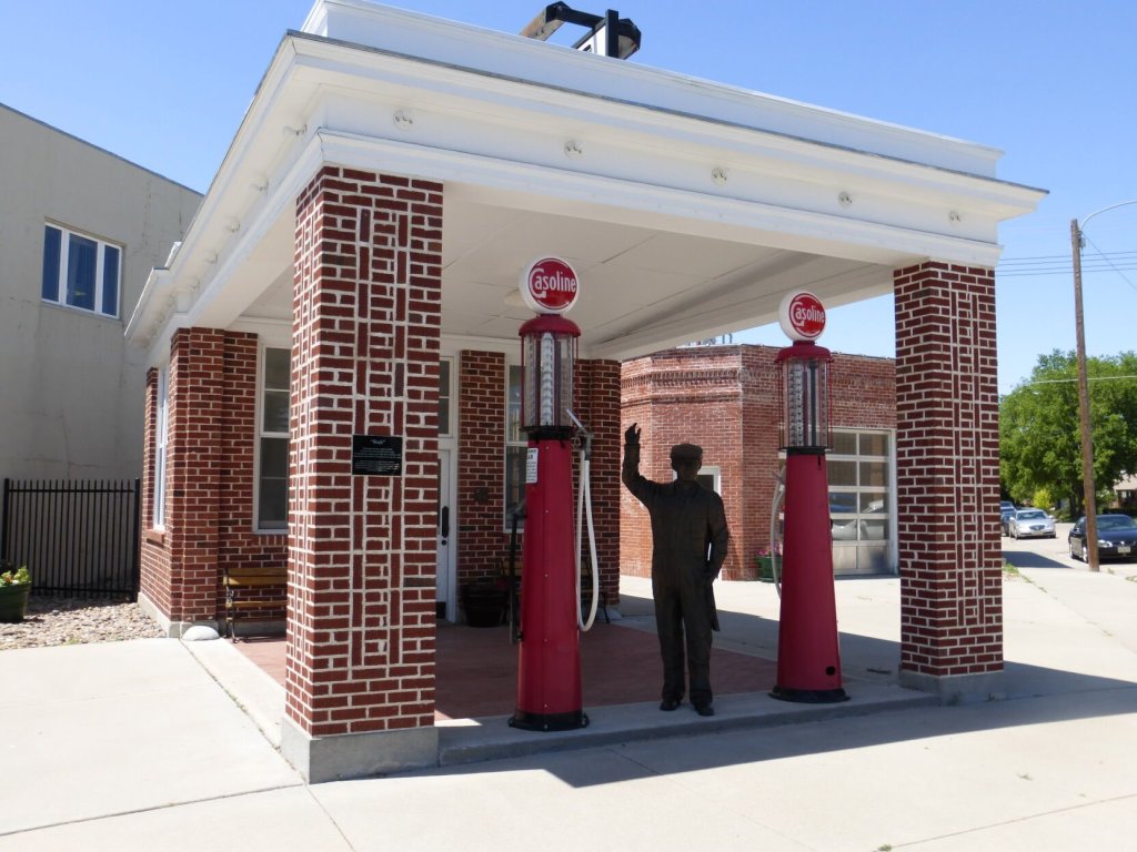
- The Spruce Street Standard Oil Station on the Lincoln Highway in Ogallala, Nebraska, was built in 1922 and renovated in 2002-03.
For most travelers “road trip” brings to mind a vehicle journey in which the destination is less important than the experience of getting there. A leisurely drive along Route 66, U.S. 1, or the Pacific Coast Highway would certainly qualify.
More modest, but equally enjoyable candidates, might include the Blue Ridge Parkway or Highway A1A along Florida’s East Coast. Seldom mentioned by even experienced travelers is the granddaddy of them all, the Lincoln Highway.
What a shame because America’s first transcontinental roadway connecting New York’s Times Square with San Francisco’s Lincoln Park is a history-filled journey like no other.
Evolution of Travel in the Early-20th Century
Interstate transportation was dominated by railroads in the early 1900s, a time when roads, mostly unpaved, were the responsibility of individual communities, counties, townships or the families that used them.
Automobiles had been around since the turn of the century, but most were expensive, and it wasn’t until 1908, when Ford Motor Company began mass-producing the Model T, that middle-class families began purchasing motor cars.
The increase in vehicle ownership and the public’s desire for more and better roads resulted in governments providing funding matches for financing road construction.
About the same time, businessman Carl Fisher, owner of a firm that manufactured automobile and truck headlights, began promoting a coast-to-coast hard-surface highway. Fisher looked to the automotive and related industries to provide financial support for fulfilling his dream. With pledges from important individuals and businesses the project gained steam and the proposed highway was named after one of Fisher’s heroes, Abraham Lincoln.
Getting the Project Up and Running
To get the project off the ground, the Lincoln Highway Association was formed to raise funds to be matched by government. Theodore Roosevelt and Thomas Edison, both friends of Fisher, were early contributors, as was then U.S. President Woodrow Wilson. The majority of Association funds were spent for publicity which proved successful in that most work on the highway — much of which was a gravel trail — was funded and completed by government.
The highway’s proposed 3,400-mile route through 13 states was announced Sept. 14, 1913. New York City’s famed Times Square was a natural eastern base, while Lincoln Park in San Francisco was selected as the western terminus. The route would be altered and the distance decreased over the years.
Traffic was sparse during first few years after the highway’s completion, but journeys picked up after the Lincoln Highway Association began publishing a guide containing information about towns along the way. The guide also offered driving advice and suggestions for spare equipment to take along. Depending on the number and length of side-trips, the journey required from 20 to 30 days, assuming a ten-hour day at an average speed of 18 miles-per-hour.
By the mid-1920’s numerous municipal campgrounds had been established along the route. These were followed by private cabin camps, also referred to as tourist camps or motor courts, on the edge of towns.
One of the final acts of the Lincoln Highway Association was designating a marker— a bronze head of Lincoln with the highway logo and a blue directional arrow — for the Lincoln Highway. On September 1, 1928, at 9 a.m., three thousand concrete makers were placed coast-to-coast by members of the Boy Scouts at one-mile intervals along the highway’s original route. Some of these historical markers remain today to mark our country’s first transcontinental highway.
For today’s traveler, the Lincoln Highway offers one of America’s premiere extended road trips. From New York City’s Times Square to San Francisco’s Lincoln Park the highway passes through 12 states, each with interesting attractions that include the Thomas Edison Monument (Edison, NJ), The Coffee Pot (Bedford, Pa.), Pro Football Hall of Fame (Canton, Ohio), Studebaker National Museum (South Bend, Ind.), Fort Bridger (Wyo.), and the original road over California’s Donner Pass.
The Lincoln Highway parallels much of the Oregon-California Trail across Nebraska and the famed “Loneliest Road in America (U.S. 50) through Central Nevada.
The time required for driving the entire length of the highway depends on how much someone wants to see. According to Kay Shelton Kozak of the Lincoln Highway Association, the drive could be done in about 10 days if someone make few stops other than for fuel, food and sleep. Seeing some places, but not everything, should take about two weeks. Taking time to explore plenty of places would likely consume about three weeks. Those who complete the trip are eligible to receive an award from the association.
For more information including maps, points of interest and history, visit the Lincoln Highway Association website (www.lincolnhighwayassoc.org).
Kay and David Scott are authors of “Exploring the Oregon Trail: America’s Historic Road Trip” (Globe Pequot). The Scotts live in Valdosta, Georgia. Visit them at blog.valdosta.edu/dlscott.


