South county dealing with sink holes, minor flooding,
Published 8:11 pm Thursday, June 28, 2012
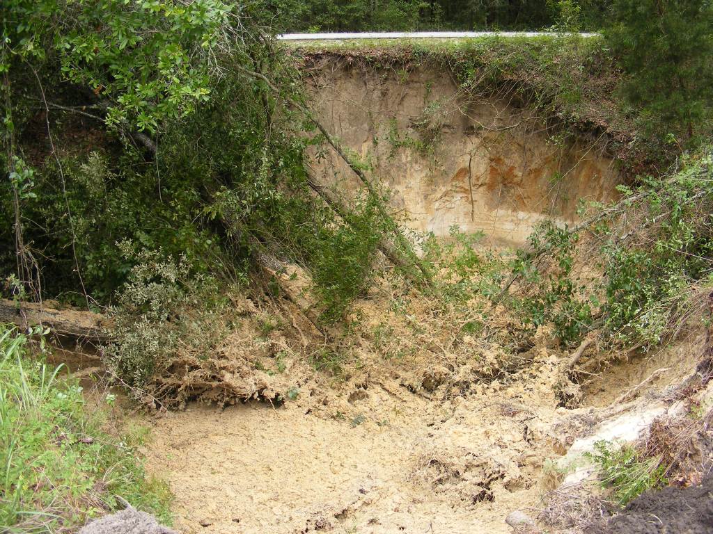
- This sink hole was discovered on Wednesday morning by Branford Public Works Director Cole Timberlake. Timberlake said it was located on the west side of US 129 between the highway and the greenway path, just north of the "dry bridge", about 50 feet outside of Branford city limits. Florida Department of Transportation is working on repairing the hole.
Suwannee and surrounding counties have been devastated by the flooding rain that came through with Tropical Storm Debby since Saturday night, although the south end of Suwannee county was not flooded nearly as bad, it had its share of the 32 sinkholes reported county-wide.
Suwannee County Sheriff Tony Cameron said that half of the sinkholes reported have been in the south end of the county. One was located on Wednesday morning by Branford Public Works Director Cole Timberlake. He found the sinkhole about 50 feet north of the “dry bridge” just outside of the city limits on the west side of US 129. The large sinkhole was located in the ditch between the highway and the greenway. Florida Department of Transportation was called to fix the hole.
“There has been very little called in for south county,” Cameron said.
“We closed the shelter because no one even checked in to it.” The emergency shelter at Branford Elementary School will be reopened if there is a need for it Cameron said.
Cameron said that in the coming days the Suwannee and the Santa Fe rivers will rise to flood stage. “The rivers will reach flood stage by Sunday, but it will be minor,” Cameron said. “Three Rivers Estates will have some problems, especially on the roads that run along the river.”
On Tuesday, water was rushing from the flooded parking lot at Ivey Memorial Park down both of the boat ramps. A section of the parking lot is currently closed. If the Suwannee River reaches the forecast flood stage of 28.4 feet, it will be approximately two feet deep in the parking lot.
According to the National Weather Service, the historical crest for the Suwannee River was 38.88 feet on April 11, 1948. The anticipated water level for the Santa Fe River at the US 129 bridge is 26.1 feet, which is moderate level flooding. At this stage the Sandy Point Campground and portions of Three Rivers Estates will be underwater. Flood stage for the Santa Fe at this checkpoint is 21 feet. The last time it reached moderate stage flooding was March 1, 1998, at 27.53 feet. The NWS recorded the historical high for the Santa Fe River, at 34.19 feet, on April 12, 1948.
To report damages to homes, structures or sink holes please contact the Suwannee County Emergency Operations Center at 386-364-3405.