Severe weather expected Sunday morning
Published 3:04 pm Saturday, March 15, 2025


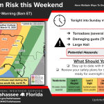

VALDOSTA — The National Weather Service is warning of severe weather expected to hit the area Sunday morning.
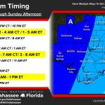
A broken squall line is expected to push across the area from west to east overnight tonight into Sunday morning, according to a weather service release on Saturday.
Places west of Valdosta are in an area of Slight Risk, the NWS said. That means scattered severe storms are possible. Areas to the east are Marginal Risk, which means isolated severe storms are possible.
Trending
Areas farther west, such as Tifton, Moultrie and Albany, are at higher risk for severe weather, the NWS said, and they’ll be hit earlier.
Tornadoes are possible up to EF2 or possibly higher. So are damaging winds of 60-70 miles an hour and large hail.
The weather service said the storm could arrive in the Valdosta area as early as 6 a.m. but more likely between 8 a.m. and 1 p.m. It will have moved out of the area by 3 p.m.
The National Weather Service said it’s very important that you have multiple ways to receive emergency notifications, such as by television, by alerts on your cell phone or by NOAA weather radio.